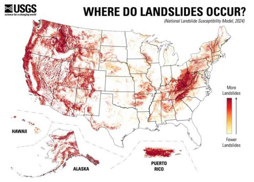
A recent study conducted by the U.S. Geological Survey has revealed that approximately 85 million people in the United States reside in areas that are prone to landslides. Moreover, during the day, 75 million Americans are at risk of landslides. The state with the highest number of people at risk is California, while West Virginia and Puerto Rico have the highest proportion of residents in landslide-prone areas. Although mountainous regions face the highest threat of landslides, nearly 44% of the U.S. has the potential to experience landslide activity.
The study, published in the peer-reviewed journal AGU Advances on September 11, 2024, introduced a new map that provides a detailed assessment of landslide risks on a county-by-county basis. This level of granularity in the mapping is beneficial for various stakeholders including urban planners, engineers, emergency managers, and homeowners. The map indicates areas with the highest susceptibility to landslides in red, those with lower risk in yellow, and regions with negligible risk in white.
The team behind the creation of this map utilized an inventory of almost 1 million past landslides, high-resolution national elevation data from the USGS 3D Elevation Program, and advanced computing techniques to develop a comprehensive landslide susceptibility model. Unlike earlier maps that focused primarily on high-risk areas, this new map also considers regions with moderate slopes where significant development and infrastructure exist.
According to the USGS, landslides are characterized by the movement of a mass of rock, debris, or earth down a slope. They encompass various types of movement such as falls, topples, slides, spreads, and flows, which can include events like rockfalls and mudslides. Landslides can be triggered by a combination of factors including rainfall, snowmelt, changes in water level, earthquakes, volcanic activity, human activities, and more. In underwater environments, submarine landslides can also occur, sometimes leading to tsunamis that impact coastal areas.
In conclusion, the new landslide susceptibility map from the USGS offers valuable insights into areas across the United States that are at risk of landslides. By leveraging this information, individuals and communities can better prepare and mitigate the potential hazards associated with landslides. To explore the interactive map and learn more about landslide risks, visit the official USGS website.